Cemetery Data Comes to Life in ArcGIS Online
Author: Gavin Jaravata Published: September 29, 2021A recurring theme in GIS is utilizing technology to prevent crucial data from being lost to time. Recording data, managing it, and exchanging it from hand to hand over time leads to vulnerabilities. Cemetery data is one such example. Imagine how a city would have handled its records a hundred years ago versus how it could manage their data now. Gone are the days where data needs to live in stacks of binders, faded old drawings, and the institutional knowledge of a soon-to-be-retired coworker. Through ArcGIS Online, it is possible to consolidate decades worth of data into an interactive cemetery web mapping application that doubles as a data management system.
What’s so great about cemetery web applications?
You may ask, why would a local government agency need a cemetery web application? As we touched upon earlier, it’s organized. Cemetery data often comes with all types of documents—illegible paper records, excessively marked up diagrams, and drawings that represent the cemetery’s layout. Through the cemetery web app, we can take all those different pieces of data, mark-ups included, and pull them into a single database. A digitized layout of the cemetery is overlaid across a map of the actual location. This allows the user to both visualize how the cemetery looks and access information from all those different data sources that now live in the database.

Is mapping and recording cemetery data online easy?
Yes! The cemetery web app also helps internal staff with clean recordkeeping. Often, that internal staff consists of one to two individuals. The details for a single person include date of birth, date of death, age at time of death, gender, whether that person served in the military, etc. It’s a lot to keep track of, especially when one needs to locate a logbook, of which there may be many, to write down all these details for the deceased in question. With so much to do and keep track of, some things inevitably will slip through the cracks, which can evolve into significantly larger issues.
Using the cemetery web app, we can simplify the recordkeeping process while retaining every necessary piece of data. All a staff member needs to do is click on the grave where the deceased is buried and update their specific details via simple form fields. This new workflow helps mitigate data entry errors as things such as misspellings can be corrected on the fly, and dropdown menus can be added for even better data integrity.
How do web apps make cemetery data more available to the public?
Whether a member of the public wanted to inquire about lot availability or locate the burial site of a relative, instead of calling the office managing the cemetery, they can instead open the application via web browser or mobile and see an instant visual representation of all lots available for purchase or search by name in the app’s search bar. Public or internal, the app’s efficiency is evident.
What features do cemetery web apps use?
Perhaps most importantly, the cemetery app is user-friendly. Through widgets, users can utilize the app to serve several purposes. The widgets we primarily use for our clients are Search, Edit, Filter, and Query.
The Search widget creates the app’s search bar. This allows the public to quickly locate their loved one’s on a map, and provides data management teams quick access to find cemetery data on an individual.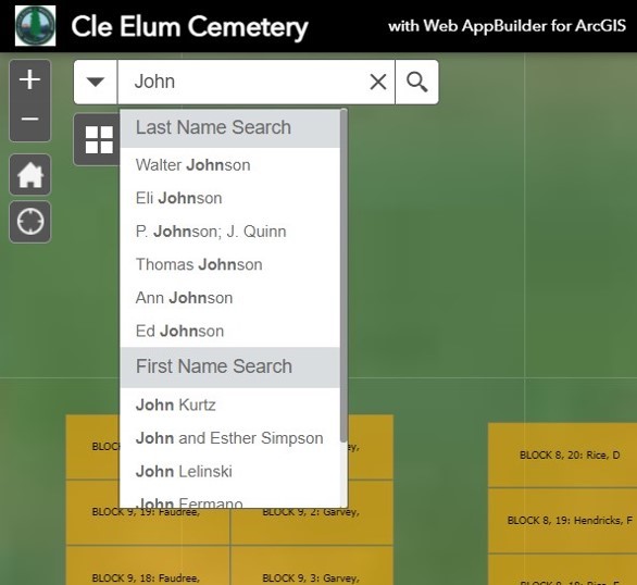
The Edit widget allows for on-the-fly edits of an individual’s specific details which further helps internal staff with recordkeeping. You can see how much easier it is to enter information in the fields than it would be to keep a book of handwritten data.

Next, the Filter widget can be set-up in a few ways; for the cemeteries we’ve worked on, we have used it to display grave vacancy. All a user needs to do is switch the filter on and they can instantly see all lots available for purchase.

Finally, the Query widget is used to identify areas that meet query criteria. For example, let’s say someone wants to find out if the area where their family is buried has open lots. If they know which section and which block their family is located, all they must do is input that information using the Query widget’s drop-down menus, and the app will take them to that area. With the help of these widgets, we provide an app that is simple in its design yet effective in its function.

Managing cemetery data can be easier. With ArcGIS Online, we can spark some life into cemetery data management systems and provide a solution that satisfies both internal staff and the public. Proper data management is always a tricky process and made all the more difficult by niche data and lack of precedent for how to approach it. With innovative minds and the right tech, we dive into those parts unknown and come up with something that is effective, efficient, and user-friendly; even if that data almost literally lives in the dirt!
Interested in what else our GIS and Data Management teams can do?
Contact Us

Gavin Jaravata
GIS Analyst
(206) 724-0614
Explore Our Work
-
3D Terrain Model Saves Time and Money
Client: Potlatch
-
Aerial Maps Reveal Flooding Impacts on Farmland
Client: Plas Newydd Farm
-
Land Redevelopment Project Takes Flight with Aerial Imagery and Mapping
Client: ELESCO Limited